
1. Introduction | Class 9 Physical Features of India Notes
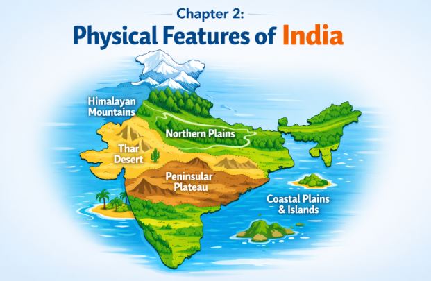
Hello students! Welcome to the second chapter of your Class 9 Geography journey. You have already learnt that India is a vast country with varied land forms. Whether you live in the plains or in hilly regions, you will notice that our country practically has all major physical features of the earth, including mountains, plains, deserts, plateaus, and islands.
Geologically speaking, the Peninsular Plateau constitutes one of the ancient landmasses on the earth’s surface and is considered a very stable land block. On the other hand, the Himalayas and the Northern Plains are the most recent landforms. The whole mountain system of Himalaya represents a very youthful topography filled with high peaks, deep valleys, and fast-flowing rivers. Let’s explore these fascinating physiographic divisions together!
2. The Himalayan Mountains
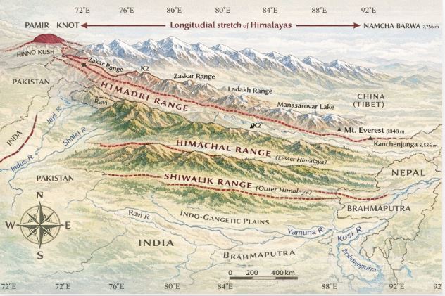
The Himalayas are geologically young and structurally fold mountains that stretch across the northern borders of India. These mountain ranges run in a west-east direction from the Indus river to the Brahmaputra river. They represent some of the loftiest and most rugged mountain barriers in the world, forming an arc that covers a distance of about 2,400 Km.
The Himalaya consists of three parallel ranges in its longitudinal extent. The northern-most range is the Great or Inner Himalayas, also known as the Himadri, which contains the loftiest peaks. To its south lies the lesser Himalaya or Himachal, known for its rugged terrain and beautiful hill stations. The outer-most range is called the Shiwaliks, which is composed of unconsolidated sediments. Beyond the Dihang gorge in the east, the Himalayas bend sharply to the south to form the Purvachal or the Eastern hills and mountains.
3. The Northern Plain
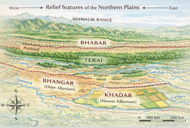
Moving south from the mountains, we find the fertile Northern Plain, which has been formed by the interplay of three major river systems: the Indus, the Ganga, and the Brahmaputra. This plain is formed entirely of alluvial soil and spreads over a massive area of 7 lakh sq. km. Because of its rich soil cover, adequate water supply, and favourable climate, it is a densely populated and agriculturally productive part of India.
The Northern Plain is broadly divided into three sections: the Punjab Plains in the west, the Ganga plain in the middle, and the Brahmaputra plain in the east. Based on variations in relief features, we can further divide these plains into four regions: the pebbly bhabar belt, the marshy and swampy terai region, the older alluvium called bhangar (which contains kankar deposits), and the highly fertile newer deposits known as khadar.
4. The Peninsular Plateau
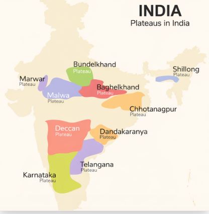
The Peninsular plateau is a tableland composed of old crystalline, igneous, and metamorphic rocks. It was formed due to the breaking and drifting of the ancient Gondwana land. This large plateau consists of two broad divisions: the Central Highlands and the Deccan Plateau. The Central Highlands lie to the north of the Narmada river and cover a major area of the Malwa plateau.
The Deccan Plateau is a triangular landmass located to the south of the river Narmada. Its western and eastern edges are marked by the Western Ghats and the Eastern Ghats, respectively. The Western Ghats are continuous and higher, with an average elevation of 900-1600 metres, whereas the Eastern Ghats are discontinuous and lower, averaging around 600 metres. One of the distinct features of this plateau is the black soil area known as the Deccan Trap, which is of volcanic origin.
5. The Indian Desert and The Coastal Plains
Towards the western margins of the Aravali Hills lies the Indian desert. It is an undulating sandy plain covered with sand dunes, primarily barchans (crescent-shaped dunes). This arid region receives very low rainfall, dropping below 150 mm per year, and is characterized by low vegetation cover. The Luni is the only large river found in this region.
Flanking the Peninsular plateau on its eastern and western edges are narrow coastal strips. The western coast is sandwiched between the Western Ghats and the Arabian Sea. It consists of the Konkan in the north, the Kannad Plain centrally, and the Malabar coast in the south. The eastern coastal plains along the Bay of Bengal are much wider and level, featuring the Northern Circar in the north and the Coromandel Coast in the south. Large rivers like the Mahanadi and Godavari have formed extensive deltas here.
6. The Islands
In addition to our vast mainland, India takes pride in its two major groups of islands. Lying close to the Malabar coast of Kerala in the Arabian Sea is the Lakshadweep Islands group. This group covers a small area of 32 sq km and is uniquely composed of small coral islands. Kavaratti island serves as its administrative headquarters.
On the other side, extending from north to south in the Bay of Bengal, are the Andaman and Nicobar islands. They are bigger in size, more numerous, and highly scattered. It is believed that these islands are an elevated portion of submarine mountains. These island groups not only hold great strategic importance for our country but also boast immense diversity in flora and fauna. They even host India’s only active volcano on Barren Island.
7. Key Takeaways
- India features a diverse topography encompassing mountains, plains, deserts, plateaus, and islands.
- The geologically youthful Himalayas form India’s northern border and consist of the Himadri, Himachal, and Shiwalik ranges.
- The Northern Plains are densely populated, agriculturally rich regions formed by alluvial deposits from the Indus, Ganga, and Brahmaputra rivers.
- The Peninsular plateau is an ancient, stable landmass composed of old crystalline, igneous, and metamorphic rocks.
- The Indian Desert is a sandy, arid region on the western margins of the Aravali Hills receiving less than 150 mm of rainfall annually.
- India is flanked by two coastal strips and possesses two island groups: Lakshadweep (coral origin) and Andaman & Nicobar (submarine mountain origin).
8. Practice Section: Master the Chapter!
Test your knowledge with these carefully crafted questions based on the notes above.
Part A: True or False (10 Questions)
- The whole mountain system of Himalaya represents a very youthful topography.
- The northern plains are formed of black soil.
- The Peninsular plateau was formed due to the breaking and drifting of the Gondwana land.
- The Eastern Ghats are continuous and can be crossed through passes only.
- Luni is the only large river in the Indian Desert.
- The newer, younger deposits of the northern floodplains are called bhangar.
- The Deccan Plateau lies to the north of the river Narmada.
- The Lakshadweep islands are composed of small coral islands.
- Majuli is the largest inhabited riverine island in the Brahmaputra river.
- The Western Ghats are higher than the Eastern Ghats.
Click to view True/False Answers
- True
- False (They are formed of alluvial soil)
- True
- False (The Western Ghats are continuous, the Eastern Ghats are discontinuous)
- True
- False (The newer deposits are called khadar)
- False (It lies to the south of the river Narmada)
- True
- True
- True
Part B: Multiple Choice Questions (10 Questions)
- Which of the following is the northern-most range of the Himalayas?
A) Himachal
B) Shiwaliks
C) Himadri
D) Purvachal - The wet, swampy, and marshy region south of the bhabar belt is known as:
A) Khadar
B) Terai
C) Bhangar
D) Kankar - What type of soil predominantly forms the Deccan Trap?
A) Alluvial soil
B) Red soil
C) Laterite soil
D) Black soil - The western coastal strip, south of Goa is referred to as:
A) Coromandel
B) Kannad
C) Konkan
D) Northern Circar - Which is the highest peak in the Eastern Ghats?
A) Anai Mudi
B) Kanchenjunga
C) Mahendragiri
D) Doda Betta - Mountain ranges in the eastern part of India forming its boundary with Myanmar are collectively called:
A) Himachal
B) Uttarakhand
C) Purvachal
D) Shiwaliks - A landmass bounded by sea on three sides is referred to as a:
A) Coast
B) Island
C) Peninsula
D) Plateau - Which river marks the eastern-most boundary of the Himalayas?
A) Ganga
B) Indus
C) Brahmaputra
D) Teesta - The part of the Himalayas lying between the Satluj and Kali rivers is known as:
A) Punjab Himalayas
B) Kumaon Himalayas
C) Nepal Himalayas
D) Assam Himalayas - Where is India’s only active volcano located?
A) Barren island
B) Kavaratti
C) Pitti island
D) Majuli
Click to view MCQ Answers
- C) Himadri
- B) Terai
- D) Black soil
- B) Kannad
- C) Mahendragiri
- C) Purvachal
- C) Peninsula
- C) Brahmaputra
- B) Kumaon Himalayas
- A) Barren island
Part C: Short Answer Questions (5 Questions)
- What is the bhabar?
- Name the three major divisions of the Himalayas from north to south.
- Which plateau lies between the Aravali and the Vindhyan ranges?
- Name the island group of India having coral origin.
- What is the Deccan Trap?
Click to view Short Answers
- The bhabar is a narrow belt of about 8 to 16 km in width lying parallel to the slopes of the Shiwaliks where rivers deposit pebbles after descending from the mountains.
- The three major divisions of the Himalayas from north to south are the Great or Inner Himalayas (Himadri), the lesser Himalaya (Himachal), and the Shiwaliks.
- The Malwa plateau, which is a significant portion of the Central Highlands, lies between the Aravali and the Vindhyan ranges.
- The Lakshadweep Islands group, situated close to the Malabar coast of Kerala, has a coral origin.
- The Deccan Trap is the distinctive black soil area of the Peninsular plateau, which is of volcanic origin and is composed primarily of igneous rocks.
Part D: Long Answer Questions (5 Questions)
- Distinguish between Bhangar and Khadar.
- Contrast the relief of the Himalayan region with that of the Peninsular plateau.
- Give an account of the Northern Plains of India.
- Write a short note on the Indian Desert.
- Differentiate between the Western Ghats and the Eastern Ghats.
Click to view Long Answers
- Bhangar refers to the largest part of the northern plain formed of older alluvium, presenting a terrace-like feature above the floodplains, and containing calcareous deposits locally known as kankar. In contrast, khadar comprises the newer, younger deposits of the floodplains that are renewed almost every year, making them highly fertile and ideal for intensive agriculture.
- The Peninsular plateau is an ancient, stable landmass composed of old crystalline, igneous, and metamorphic rocks, featuring gently rising hills and wide, shallow valleys. On the other hand, the Himalayan mountains form an unstable, youthful topography of recent fold mountains characterized by highly rugged terrain, high peaks, deep valleys, and fast-flowing rivers.
- The Northern Plain has been formed by the interplay of the Indus, the Ganga, and the Brahmaputra rivers and their tributaries. Covering an area of 7 lakh sq. km, it is formed of fertile alluvial soil and is a densely populated, agriculturally productive region. It is divided into the Punjab, Ganga, and Brahmaputra plains, and structurally features four regions: bhabar, terai, bhangar, and khadar.
- The Indian desert lies towards the western margins of the Aravali Hills as an undulating sandy plain covered extensively with sand dunes, such as barchans. It experiences an arid climate with extremely low rainfall of less than 150 mm per year and has a low vegetation cover. Streams appear only briefly during the rainy season, and the Luni is the sole large river draining this region.
- The Western Ghats run parallel to the western coast, are continuous, and can only be crossed through passes. They are relatively high, with an average elevation of 900-1600 metres, and feature peaks like Anai Mudi. The Eastern Ghats stretch from the Mahanadi Valley to the Nigiris in the south. They are discontinuous, irregular, dissected by rivers draining into the Bay of Bengal, and have a lower average elevation of 600 metres, with Mahendragiri being the highest peak.
Read Also: Class 9 Social Science (Contemporary India) All Chapters
For official syllabus and textbooks, visit the NCERT Official Website.