
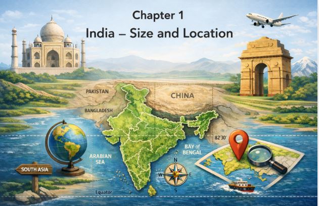
1. Introduction | Class 9 India Size and Location Notes
Hello students! Welcome to the very first chapter of your Class 9 Geography journey. India is an incredibly special country because it is one of the most ancient civilisations in the world. Over the last five decades, our nation has achieved multi-faceted socio-economic progress.
We have moved forward by displaying remarkable progress in agriculture, industry, technology, and overall economic development. Furthermore, India has contributed significantly to the making of world history. In this chapter, we will explore the precise location of our vast country and understand its physical size. Let’s begin!
2. The Location of India
To understand exactly where India is on the world map, we use imaginary lines known as latitudes and longitudes.
India is a vast country lying entirely in the Northern hemisphere. The mainland extends precisely between the latitudes 8°4’N and 37°6’N. Longitudinally, it stretches between 68°7’E and 97°25’E.
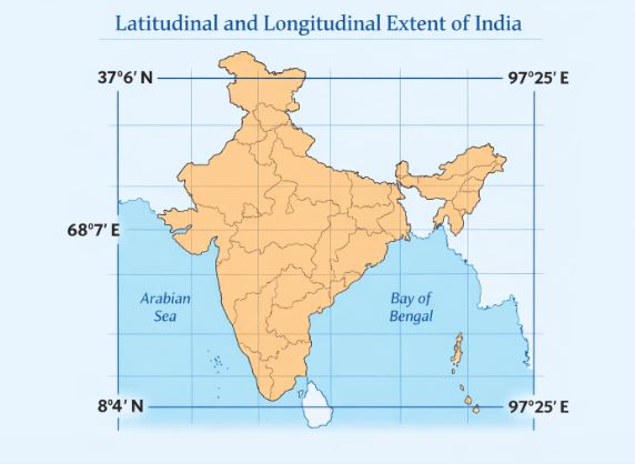
Figure-1: Map showing India’s Latitudinal (8°4’N to 37°6’N) and Longitudinal (68°7’E to 97°25’E) Extent.
An important imaginary line called the Tropic of Cancer (23°30’N) passes right through the country, dividing it into almost two equal parts. Beyond the mainland, we also have island groups. To the southeast lies the Andaman and Nicobar islands in the Bay of Bengal. To the southwest, we have the Lakshadweep islands in the Arabian Sea.
3. Size and Geographical Boundaries
When it comes to size, India holds a massive presence on the global map.
The land mass of India covers an enormous area of 3.28 million square km. This area accounts for about 2.4 per cent of the total geographical area of the entire world. Because of this vast expanse, India proudly stands as the seventh largest country in the world.
Our country also has extensive boundaries. India has a land boundary of about 15,200 km. The total length of our coastline, which includes the mainland, Andaman and Nicobar, and Lakshadweep islands, is 7,516.6 km. Geographically, India is bounded by young fold mountains in the northwest, north, and northeast. As we move south of about the 22° north latitude, the land begins to taper and extends towards the Indian Ocean. This extension divides the ocean into two seas: the Arabian Sea on the west and the Bay of Bengal on the east.
4. Time and the Standard Meridian
An interesting geographic fact is that the latitudinal and longitudinal extent of the mainland is roughly 30°. Even with this fact, the east-west extent appears to be smaller than the north-south extent.
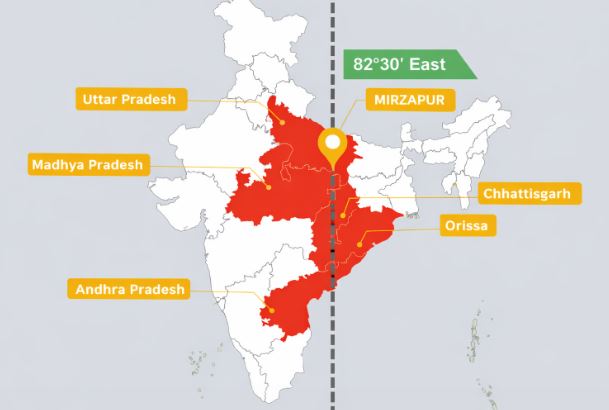
Figure-2: The Standard Meridian of India (82°30’E) passing through Mirzapur, Uttar Pradesh.
Because the longitudinal spread is so wide, there is a time lag of two hours as you move from Gujarat to Arunachal Pradesh. If every place followed its own local time, it would cause massive confusion. Therefore, the time along the Standard Meridian of India is taken as the standard time for the whole country. This meridian is at 82°30’E and passes through Mirzapur in Uttar Pradesh. Additionally, the latitudinal extent influences the duration of day and night as a person moves from south to north.
5. India’s Connection with the World
India enjoys a highly strategic and central location between East Asia and West Asia. Our country is effectively a southward extension of the Asian continent. The trans-Indian Ocean routes, which connect the countries of Europe in the West to the countries of East Asia, provide India with this prime strategic location.
The Deccan Peninsula protrudes deeply into the Indian Ocean. This helps India establish close contacts with West Asia, Africa, and Europe from the western coast, and with Southeast and East Asia from the eastern coast. In fact, no other country has a long coastline on the Indian Ocean quite like India, which justifies the ocean being named after it.
It is important to note that India’s relationships through land routes are much older than her maritime contacts. The various mountain passes in the north provided passages for ancient travellers when oceans restricted interaction. These ancient routes contributed significantly to the exchange of ideas and commodities. The ideas of the Upanishads, the Ramayana, the stories of Panchtantra, and the Indian numerals and decimal system reached many parts of the world this way. Spices, muslin, and other merchandise were taken from India abroad. Conversely, we can see the influence of Greek sculpture and West Asian architectural styles of domes and minarets in different parts of our country.
6. India’s Neighbours
India occupies an important strategic position in South Asia and currently consists of 28 states and Eight Union Territories.
We share our vast land boundaries with several neighbouring countries. In the northwest, we border Pakistan and Afghanistan. In the north, we share borders with China (Tibet), Nepal, and Bhutan. Moving to the east, our neighbours are Myanmar and Bangladesh.
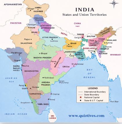
Figure-3: Political Map of India highlighting its land boundaries and neighbouring countries.
Our southern neighbours across the sea consist of two specific island countries: Sri Lanka and Maldives. Sri Lanka is separated from India by a narrow channel of sea formed by the Palk Strait and the Gulf of Mannar. Meanwhile, the Maldives Islands are situated to the south of the Lakshadweep Islands.
7. Key Takeaways
- India lies entirely in the Northern hemisphere, situated between latitudes 8°4’N and 37°6’N and longitudes 68°7’E and 97°25’E.
- The Tropic of Cancer (23°30’N) divides the country into almost two equal parts.
- With a land mass of 3.28 million square km, India accounts for 2.4 per cent of the world’s area, making it the seventh largest country.
- To manage the two-hour time lag from west to east, 82°30’E passing through Mirzapur is taken as the Standard Meridian.
- India’s central location at the head of the Indian Ocean provides strategic trade routes connecting Europe and East Asia.
- Ancient land routes through mountain passes are older than sea routes and facilitated the exchange of goods and ideas like the decimal system.
- India shares borders with Pakistan, Afghanistan, China, Nepal, Bhutan, Myanmar, and Bangladesh, alongside island neighbours Sri Lanka and Maldives.
8. Practice Section: Master the Chapter!
Test your knowledge with these carefully crafted questions based on the notes above.
Part A: True or False (10 Questions)
- India is located entirely in the Southern hemisphere.
- The Tropic of Cancer divides the country into almost two equal parts.
- India’s land mass has an area of exactly 5 million square km.
- India is the seventh largest country in the world by area.
- There is a time lag of four hours between Gujarat and Arunachal Pradesh.
- The Standard Meridian of India passes through Mirzapur in Uttar Pradesh.
- India’s maritime contacts with the world are older than her land route contacts.
- The opening of the Suez Canal in 1869 reduced India’s distance from Europe by 7,000 km.
- Sri Lanka is separated from India by the Palk Strait and the Gulf of Mannar.
- Maldives Islands are situated to the north of the Lakshadweep Islands.
Click to view True/False Answers
- False (It lies entirely in the Northern hemisphere)
- True
- False (It has an area of 3.28 million square km)
- True
- False (There is a time lag of two hours)
- True
- False (Relationships through land routes are much older than maritime contacts)
- True
- True
- False (They are situated to the south of the Lakshadweep Islands)
Part B: Multiple Choice Questions (10 Questions)
- Which imaginary line divides India into almost two equal halves?
A) Equator
B) Tropic of Capricorn
C) Tropic of Cancer
D) Prime Meridian - What is the percentage of India’s total area compared to the world’s total geographical area?
A) 1.5 per cent
B) 2.4 per cent
C) 3.5 per cent
D) 5.2 per cent - Which longitude is taken as the Standard Meridian of India?
A) 68°7’E
B) 97°25’E
C) 82°30’E
D) 23°30’N - What is the total length of the coastline of the mainland, including the island groups?
A) 15,200 km
B) 7,516.6 km
C) 3.28 million km
D) 7,000 km - Which island group of India lies to its southeast in the Bay of Bengal?
A) Lakshadweep
B) Maldives
C) Andaman and Nicobar
D) Sri Lanka - Which of these countries does NOT share a land boundary with India?
A) Pakistan
B) China
C) Nepal
D) Sri Lanka - South of which latitude does the Indian landmass begin to taper?
A) 22° north latitude
B) 30° north latitude
C) 23°30′ north latitude
D) 8°4′ north latitude - Which canal’s opening in 1869 reduced the distance between India and Europe?
A) Panama Canal
B) Suez Canal
C) Kiel Canal
D) Corinth Canal - The trans-Indian Ocean routes connect the countries of Europe in the West to the countries of:
A) North America
B) South America
C) East Asia
D) Antarctica - How many States does India currently have?
A) 25
B) 27
C) 28
D) 29
Click to view MCQ Answers
- C) Tropic of Cancer
- B) 2.4 per cent
- C) 82°30’E
- B) 7,516.6 km
- C) Andaman and Nicobar
- D) Sri Lanka
- A) 22° north latitude
- B) Suez Canal
- C) East Asia
- C) 28
Part C: Short Answer Questions (5 Questions)
- Name the island group of India lying in the Arabian Sea.
- What is the area of India’s landmass?
- Which city in Uttar Pradesh does the Standard Meridian of India pass through?
- Name the two island countries that are our southern neighbours.
- What ancient Indian ideas and systems reached many parts of the world through land routes?
Click to view Short Answers
- The Lakshadweep islands lie in the Arabian Sea.
- The land mass of India has an area of 3.28 million square km.
- The Standard Meridian passes through Mirzapur in Uttar Pradesh.
- Our southern island neighbours are Sri Lanka and Maldives.
- The ideas of the Upanishads, the Ramayana, the stories of Panchtantra, and the Indian numerals and decimal system reached many parts of the world.
Part D: Long Answer Questions (5 Questions)
- Describe the size and geographical boundaries of India.
- Why is 82°30’E selected as the Standard Meridian of India?
- How has India’s central location at the head of the Indian Ocean helped it?
- Differentiate between India’s land routes and maritime contacts in ancient times.
- List the neighbouring countries of India based on their geographical direction.
Click to view Long Answers
- India has an area of 3.28 million square km, accounting for 2.4 per cent of the world’s geographical area, making it the seventh largest country. It has a land boundary of about 15,200 km and a coastline of 7,516.6 km. The country is bounded by young fold mountains in the northwest, north, and northeast. South of 22° north latitude, it tapers and extends into the Indian Ocean, dividing it into the Arabian Sea and the Bay of Bengal.
- Because the latitudinal and longitudinal extent of the mainland is roughly 30°, there is a significant time lag of two hours from Gujarat to Arunachal Pradesh. To avoid differences in local time and ensure a uniform schedule across the vast nation, the meridian 82°30’E passing through Mirzapur is taken as the standard time for the whole country.
- India’s central location lies right between East and West Asia. Because it is a southward extension of the Asian continent, it sits centrally on trans-Indian Ocean routes connecting Europe and East Asia. The Deccan Peninsula protruding into the ocean helps India maintain close trade and cultural contacts with West Asia, Africa, and Europe from its western coast, and with Southeast and East Asia from its eastern coast.
- India’s relationships through land routes are much older than her maritime contacts. The mountain passes in the north provided passages to ancient travellers, whereas the oceans restricted such interactions for a long time. These land routes were crucial for the ancient exchange of ideas like the Upanishads and the decimal system, as well as commodities like spices, whereas sea routes became more prominent later on.
- In the northwest, India shares land boundaries with Pakistan and Afghanistan. In the north, its neighbours are China (Tibet), Nepal, and Bhutan. In the east, it borders Myanmar and Bangladesh. Across the sea to the south, India’s island neighbours are Sri Lanka (separated by the Palk Strait and Gulf of Mannar) and Maldives (south of the Lakshadweep Islands).
Read Also: Class 9 Social Science (Contemporary India) All Chapters
For official syllabus and textbooks, visit the NCERT Official Website.